


Furuno SC Satellite Compass.
Couldn't load pickup availability
Description
Description
Furuno SC70 and SC130 Satellite Compasses
The Furuno SC70 and SC130 represent Furuno's latest generation of commercial-grade satellite compasses, offering exceptionally precise heading and attitude data to enhance the performance of marine electronics such as Radars, ARPA, Sonar, Chart Plotters, ECDIS, and Autopilots.
By utilizing multiple GNSS constellations—GPS, Galileo, GLONASS, QZSS, and SBAS—the SC70 and SC130 provide continuous, highly accurate positioning and heading information essential for safe navigation. They deliver a full suite of navigational data including GPS position, Speed Over Ground (SOG), Course Over Ground (COG), Rate of Turn (ROT), and 3-axis vessel speed critical for maneuvering, including berthing.
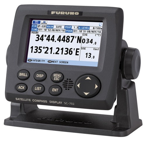
The SC70 model delivers heading accuracy of approx. 0.4°, with a rapid 40°/s follow-up rate—twice the IMO high-speed craft requirement—and features a 4.3” color LCD display with 480 x 272 WQVGA resolution. The SC130 is designed for medium to large vessels, offering higher precision sub-degree heading accuracy (0.25°) and uses the NMEA2000 interface for seamless integration.
Both compasses are maintenance-free, rugged, and ideal for retrofitting into existing navigation systems. The SC70 can be installed easily using existing antenna cabling with an optional LAN conversion kit.
Models:
-
SC70 Satellite Compass (NMEA0183)
-
SC130 Satellite Compass (NMEA2000, with 4.3" Color LCD Display)
Key Features
-
GNSS multi-constellation support (GPS, Galileo, GLONASS, QZSS, SBAS)
-
High-accuracy heading: SC70 at 0.4° RMS, SC130 at 0.25° RMS
-
Data outputs: GPS Position, SOG, COG, ROT, Speed on 3 axes (bow, stern, longitudinal)
-
Rapid follow-up rate of 40°/s (SC70 and SC130)
-
IEC and IMO compliant, Type-approved as THD, GPS, and ROTI
-
Maintenance free with no moving parts and fast startup (~90 seconds)
-
Rugged design with IP56-rated antenna unit and IP22/35 display unit
-
SC130 includes a 4.3” color LCD for data visualization
-
Compatible with NavNet TZtouch, TZtouch2, TZtouch3, and other navigation systems
-
Easy retrofit installation with existing antenna cable options
Specifications Comparison
| Feature | SC70 | SC130 |
|---|---|---|
| Data Interface | NMEA0183 | NMEA2000 |
| Heading Accuracy | 0.4° RMS | 0.25° RMS |
| Heading Update Rate | Up to 40°/s | Up to 40°/s |
| Display | 4.3" Color LCD | 4.3" Color LCD |
| Power Supply | 12–24 V DC | 12–24 V DC |
| Power Consumption | ~2.1 to 1.1 A | Similar |
| Environmental Ratings | IP56 Antenna; IP22 Display | IP56 Antenna; IP22/35 Display |
| Tracking Satellites | GPS, Galileo, GLONASS, QZSS, SBAS | Same |
| Position Accuracy | GPS ~10m; DGPS ~5m; WAAS ~3m | Same |
| Dimensions (Display) | 95 x 87.1 mm (W x H) | 95 x 87.1 mm (W x H) |
What’s in the Box
SC70
-
SC701 Junction Box
-
SC702 Display Unit
-
SC703 Antenna Unit
-
Cable assembly, Mounting hardware, Adhesives, Operator’s Manual
SC130
-
SC130 Compass Unit with Built-in Antennas and Processor
-
6m NMEA Drop Cable
-
Mounting hardware and adhesive
-
Operator’s Manual

Have a question?
Notified by email when this product becomes available
